
JUNK Book 6026
(For the PDF version of the book, click here.)
Julia’s Unequivocal Nevada Klampout #42
Clamper year 6026
Researched and fabricated by
Jeffrey D. Johnson XNGH,
Clamphistorian at Chapter 1864
Envisioned by
Noble Grand Humbug Fred Eldred
Dedicated to
The Angels of Paradise and Dallas Cheerleaders
2021 c.e.
Humboldt County
Humboldt is the oldest county in Nevada, created by the Utah Territorial Legislature in 1856. It was also one of Nevada Territory’s original nine counties created in 1861. The county is drained by the Quinn and Humboldt Rivers, much of the plains were under pluvial Lake Lahontan. The numerous mountain ranges were islands and peninsulas. They are botanical islands to this day. Unionville, in the Humboldt Range, was the first county seat until the mining boom died there and it was moved to Winnemucca on the Central Pacific Railroad in 1873. Pershing County was carved from the original County in 1919. Out of an area of 9,658 square miles 0.2% is water.
Born in Berlin Germany in 1769, Humboldt died in 1859 back in Berlin. Humboldt graduated from the Freiberg School of Mines in 1792. During his time as a mine inspector, Humboldt financed a trade school for miners. He also created an emergency relief fund for the miners, aiding them and their widders and orphans in times of need. His volumes on the natural history of the Western Hemisphere and Europe made him a hero to scientists and explorers worldwide. His life’s work in botanical geography, climatology, meteorology and more inspired John C. Fremont to name the alkaline beige river that runs and disappears in his honor in 1845.
Little Humboldt River
The South Fork of the Little Humboldt River begins in the far western area of Elko County and the North Fork drains the 6,000’ Owyhee Plateau, nearly at the Oregon border, confluencing at Chimney Reservoir. Chimney, constructed in 1974, has a storage capacity of 35,000 acre-feet. The reservoir’s water rights are owned by Ranchers and the Humboldt County Fair and Recreation Board. A natural hot spring from a travertine caldron occurs along the river where it enters Paradise Valley. Open to the public but on private property. The East slope of the Santa Rosa Range drains in to the Little Humboldt River sub basin through Martin Creek, Cottonwood Creek and many small streams. Little water, even in wet years, makes it to the river’s end at Gumboot Lake, where the flow is blocked by the Winnemucca Sand Dunes. The Little Humboldt River makes no surface water contribution to the Humboldt River main stem except rare flood years when it can break through the sand. The “White Winter” of 1889-90 was the first recorded time the Little Humboldt River became a surface water tributary to the Humboldt River’s main stem. The next recorded breakthrough of the Sand Dunes by the Little Humboldt River occurred in the flood event of March-April 1907. Similar floods took place in February-April 1910, and again in January-April, 1914. During the 1914 event the Little Humboldt River’s depth at its confluence with the Humboldt River main stem was reported at 10.5 feet. After a lengthy hiatus, in 1943, 1952 and 1984 the Little Humboldt River sub-basin met the river again. Winter Precipitation within the sub-basin ranges from 8-9 inches in Paradise Valley to 25 inches in the upper elevations of the Santa Rosa Range.
Peter Skene Ogden
The Little Humboldt River drainage was the gateway where the first White folks entered and described the Humboldt River Basin. In November 1828, Peter Skene Ogden, a trapper for the Hudson’s Bay Company, led a party of trappers comprising the Fifth Snake Country Expedition south from the Columbia River Basin. Entering Nevada near Denio, the trappers traveled south and Eastward along the Quinn River and then entered the Little Humboldt River subbasin on the 9th at Paradise Hill Pass between the Santa Rosa Range and the Bloody Run Mountains. Proceeding down the Little Humboldt, Ogden reached the Humboldt River. Ogden initially named the Humboldt simply “Unknown River”. Subsequently, Ogden was to conduct two additional expeditions into the Humboldt River Basin. Ogden’s explorations were especially important as they traced the Humboldt River from its source to its sink and produced the first maps and written descriptions of northern and central Nevada. The Humboldt River stretches 225 miles from Wells to the Sink and wanders for 600 serpentine meanders across Northern Nevada. They practiced a scorched earth policy of trapping all the beaver they could find to leave no trace for independent American trappers coming from the East.
The Santa Rosa Range
In 1866 It was known as the Cottonwood Range. Most of the Santa Rosa Range is included within the Humboldt-Toiyabe National Forest. The highest peaks in the range are Granite Peak (At 9732 feet, the highest in the County) and Santa Rosa Peak (9701 feet). In 1915 Granite Peak was still known as Spring Peak. The range is about 70 miles long from Winnemucca Mountain to the border with Oregon. It was a peninsula when Lake Lahontan was full. The Range is underlain by a sequence of Upper Triassic to Jurassic shales and sandstones that folded and metamorphosed to phyllites and quartzites prior to late Cretaceous, or early Tertiary time. Granite then intruded these formations. All of these basement rocks covered by volcanic rocks consisting of andesites, basalts, dacites, and rhyolites. Erosion removed the volcanic rocks from almost all of the main Santa Rosa Ridge. Elevations above 7,500’ show signs of glaciation. The eastern side of the range is the ranching district around Paradise Valley. The Quinn River Valley is west of the range and drains. The Owyhee Desert on the edge of the Columbia Plateau extends northeast from the north end of the range. Deer and California Bighorn flourish on the Mountain. Populations of native Lahontan Cutthroat trout survive in small isolated creeks. Groves of Aspen, Mountain Mahogany and Limber Pine populate the higher elevations. Surprisingly the predominant ground cover is sagebrush. The range was named for wild roses which grow in the area. Nevada cattle ranchers sent petitions to the Forest Service in Ogden Utah with the intention of eliminating sheperds. On July 10, 1910 a land examiner issued a paper called, “Favorable Report on the proposed Santa Rosa National Forest, Nevada.” On April 1, 1911, Presidential Proclamation 1120 established the Santa Rosa National Forest. Part of the work the US Forest Service conducted in the Santa Rosa Mountains included projects by the Civilian Conservation Corps from 1933 to 1941. Despite the lack of US Forest Service interest in Wilderness for the Santa Rosa Range The southern portion became the Santa Rosa/Paradise Peak Wilderness with the passage of the Nevada Wilderness Protection Act of 1989.
Yamasopo
Bannock, Shoshone and Paiutes from three clans shared the resources of the area. Atsa-Kudok-Wa: “Those who live in the Red Mesas” lived on the West slope of the Santa Rosas. Sawawaktödö: “Sagebrush Eaters who live in the mountains” lived in the South end of the Valley and the Yamosöpö tuviwarai “Those who live in Crescent Valley” They are all federally recognized as part of the Fort McDermitt Paiute and Shoshone Tribes. Traces of their occupation can still be seen in the area, petroglyphs and arrow heads are not uncommon.
Paradise Valley
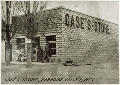
Four prospectors from Star City first climbed the ridge above Rebel Creek and saw the valley in 1863, R.D. Carr, W.C. Gregg, J.A. Whitmer and W. B. Huff. Huff proclaimed, ‘’What a Paradise!’’ Gregg quit the mining life and returned to homestead and cut Hay for the demanding market. In a year 20 ranches sprouted in the valley. The indigenous population resented the occupation of their Crescent Valley and by 1864 skirmishes began. The next year full warfare ensued bringing in the Army who pitched a fort on Big Cottonwood creek called Fort Winfield Scott in 1866. By 1869 the last renegades had been run out of the valley. Soon the area became an agriculture mecca for feeding North Central Nevada and southwest Idaho Territory as well. Scottsdale, named for the nearby Army Post, was established in 1866 by Chuck Nichols. It was renamed Paradise City in 1869. During Paradise Valley’s mining days, 1878 to 1920, the community supplied the mining camps of Queen City, Spring City and Gouge-Eye. With the decline of mining the Little Humboldt River sub-basin’s industry shifted primarily to ranching and the raising of cattle and sheep. Many old buildings remain behind the tree lined streets in the secluded community and the permanent population remains at around 100. The Volunteer Fire Dept. Father’s Day BBQ is famous in 5 counties and three states.
Saint Alphonso’s Catholic Church.
Built by Alphonso Pasquale from the Piedmont in Italy and his team of masons for the locals in 1906. It looks suspiciously like his church in Italy. The white granite in the construction came from Lamance Creek nearby. There are many historic structures in the area built to last by the Italians that homesteaded here.
Saint Alphonso
Born in the Kingdom of Naples, in 1696. He was baptized as Alphonsus Mary Anthony John Cosmas Damian Michael Gaspard de’ Liguori. He became a successful lawyer. Within ten years he’d had his fill of that. He was ordained in 1726, at 30. He lived his first years as a priest with widders and the marginalized youth of Naples. He became very popular because of his plain and simple preaching. Liguori suffered from scruples much of his adult life. Liguori was consecrated Bishop of Sant’Agata dei Goti in 1762.[10] He tried to refuse the appointment He was beatified on 15 September 1816 by Pope Pius VII and canonized on 26 May 1839 by Pope Gregory XVI. His system of moral theology is noted for its prudence, avoiding both laxism and excessive rigor.
Paradise Valley Ranger Station
From the National Landmark status report
The Paradise Valley Ranger Station presently consists of eight woodframe buildings situated in a rural community valley setting. Four of the buildings are one-story, three are one-and-a-half story and one is a split level, all with gable roofs. They are painted white with green roofs and trim. The compound represents typical structures built by the CCC and used by the U.S. Forest Service in Nevada. The buildings make up a compound which has accommodated the responsibilities associated with the management of public lands and resources. The compound occupies approximately three-fourths of an acre in the town of Paradise Valley, Nevada, and is located on the southeastern edge of town. The land was purchased from the Harvey Brothers of Paradise Valley in 1933 by the Forest Service. Much of the original landscaping and some of the sidewalks on the compound that were done by the CCC are still evident today. The compound is part of the Santa Rosa Ranger District of the Humboldt National Forest. State Route 290 runs north and south in front of the compound. Ranching and farming are the main activities in the surrounding valley. Directly across the valley to the west is a view of the eastern front of the Santa Rosa Mountains, including the Santa Rosa-Paradise Peak Wilderness area. All eight of the original structures constructed on the compound are still present today and are considered to be contributing features. They are the office, horse barn, cistern, warehouse/shop, garage, well/pump house, gas house, and dwelling. The ninth contributing feature is a two-horse barn moved onto the compound in 1908 or 1909 from the Toiyabe National Forest, and converted into a bunkhouse. All of these structures are present at this time and are used by Forest Service employees on the district. Non-contributing features present: a lodge pole corral, hay yard, horse loading dock, flag pole, concrete sidewalks and driveways, a 1000 gallon fuel tank, an enclosed hut for the current well, and the Paradise Valley Ranger Station sign.
Fort Winfield Scott
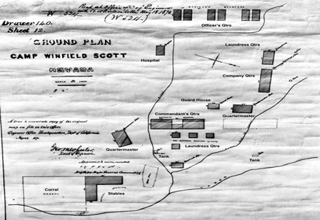
Troops of the Eighth Cavalry, co. A, under Captain Muny Davis with the help of the local Italian masons began construction of the post in December 1866. Water was obtained from Big Cottonwood Creek running through the post. The post commander in 1867 was 2d Lt. John Lafferty, 8th Cav. He was the settlers favorite and terrorized the ‘Dusky Raiders’. His new commanding officer, 1st Lt. Joseph Karge, 8th Cav. was an inferior soldier and Lafferty had to cover for him. When Camp McGarry was abandoned in September 1868, its garrison, Co C 8th Cav, was moved to Fort Scott before it was transferred to Arizona. The last troops to serve at the camp were Co I 1st Cav, under Capt. C. C. C. Carr, which arrived in September 1869. By 1869 resistance by aboriginals had ended. In 1870 troops began transferring to Camp McDermit. On 19 Feb 1871, Lieutenant O.L. Hein and his detachment joined their company at Camp McDermit and Fort Scott was abandoned. Some structures still exist on the private ranch.
Lt. John Lafferty, 8th Cav.

After his stellar performance in Nevada his Company was sent to Arizona where he received “a severe gunshot wound” in the right jaw in a battle with Apaches at Chiricahua Pass, Arizona Territory, October 20, 1869. The bullet tore away a portion of his lower jaw, took out twelve lower and four upper teeth, destroyed a portion of his tongue and lips, and left him unable to masticate his food properly. He suffered, according to Surgeon W H. Gardner in 1875, “almost constantly with Dyspepsia and is unable to digest any kinds of solid food without great pain and difficulty, the destruction of a portion of the tongue and lips also interferes materially with articulation.” Records indicate at Fort Union New Mexico territory the tenants had issues with his widder. She would just barge in to people’s residences uninvited and was generally belligerent. She did severe damage to the off post saloon. He reported ‘’Lieut Lafferty has told me on several occasions that no one could imagine his anguish of mind on account of his wife’s conduct but that he had no control over her – that he had done everything he could to pacify her but all was of no avail and that he was really afraid of her. He had been trained as a prize fighter but being smaller than his wife I am told he only succeeded in blacking her eyes, bruising her body and partly obliterating her features without accomplishing the desired end.’’ If any action was taken, the records have not been found. Lieutenant Lafferty continued to serve at Fort Union until granted sick leave in 1875. Whether his wife remained there until that time was unknown. He was promoted to rank of captain in 1876 and was recommended to the appropriate military board for retirement because of his wounds. He served in California until that recommendation was approved, and he retired on June 28, 1878. He later was accorded brevet rank for “gallant service against Indians” in 1867 and 1869. He lived until October 15, 1899.
The Micca
from Fred Eldred, NGH
Named for Alphonso Pasquale’s home town in Italy, this building was built to accommodate some of the needs of the local populace. A meat market was located in the building and a cooler constructed to house the meats, using ice from the adjoining ice storage room. Also located on the first floor, and adjacent to the meat market was a dry goods store, post office (which some of the postal boxes still remain), land office, and bar, all facing the street. In the back of the building, first floor, is a kitchen and dining area, as well as storage for foods and coal. The upper floor contains individual bedrooms, as well as apartments, an area for seating and a doctor office area. The basement area was mostly for storage, but an oven for baking bread was built, and is still standing. A law office and a beauty shop were also on the first floor. The building is locally significant to its community for the great diversity of functions it contained, all vital in their time to the life of Paradise.
Queen City
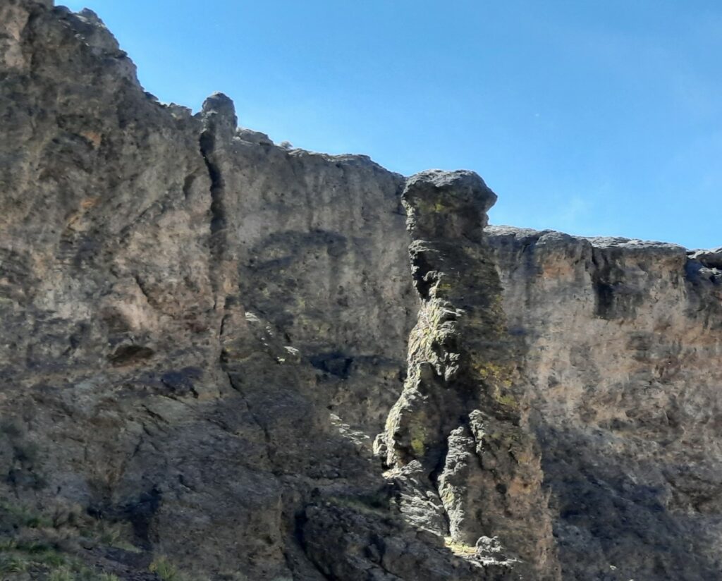
Martin Creek leaves the Mountains in a short but spectacular canyon with volcanic rock formations carved out by the creek. A County fish hatchery was here and a Swimming facility. China Dam, aka Sugarloaf Dam, was built in the canyon to supply water for the Paradise Quartz ten stamp mill and roasting furnace in 1874. You could swim under the dam till at least 1993 but the dam was removed for safety recently. The ditch and a tunnel are still just up the hill.
Silver State Flour Mill
From National landmark status information
The Mill consists of two structures, the mill building and the warehouse. The original size of the mill building was 60 feet by 30 feet, but a later addition was made and it is an “L” shape today, 80 feet on the west side. The warehouse building is 51 feet by 31 feet in size. The lower portion of the mill building is of sandstone block construction and the upper portion is rough timber covered with heavy black tar paper. The upstairs portion of the mill building houses the mill screens, rollers and the milling equipment. Downstairs, on the first floor of the mill building, there are three rooms. One large room was used to store in-coming grain and the other two were used for storing flour and other mill products, such as bran and shorts. The warehouse building is also of sandstone block construction and stands one story in height. The mill and equipment are still in operating condition, although the facility has not been used for its original purpose since the 1940s. The ditch from Martin Creek is still in existence and there is still a small producing apple orchard at the mill site. Both the mill building and the warehouse are currently in use as ranch storage facilities and both buildings are in fairly good condition. The tarpaper on the top floor of the mill building is somewhat deteriorated and needs to be replaced, but otherwise it retains much of its original appearance and architectural integrity.
The Silver State Flour Mill is of local historical significance because it was the first such facility in Humboldt County and one of the earliest in the history of Nevada. It is also of significance because of the important part it played in the economy of the town of Paradise Valley and the surrounding area. Prior to the construction of the mill, very little wheat was raised in the area as there were no facilities by which it could be turned into flour. The main crop was thus barley which required only thrashing and could be sold for $4.00 a bushel and up. Flour for the area was imported from California at a cost of $16.00 to $20.00 per 100 pounds. The question of constructing a flour mill in Paradise Valley had been under consideration since the summer of 1866, but a decision to go ahead with construction was not made until a public meeting was held at Willow Point on September 23, 1867. The chairman and secretary of the meeting were J.F. Abel and S.J. Worden respectively. At the meeting, Charles Adams said he would build a first-class mill at a cost to himself of $15,000 to $20,000 if the farmers of the area would promise him their patronage for a period of three years. Pledges of 1,275 acres were made immediately and in October and November of 1867 lumber and other building materials began to arrive. By mid-December the building had been erected and the milling equipment was promised within six weeks. Heavy snows in the Sierras impeded the movement of freight from California however and it was not until late March of 1868 that the facility was ready to mill its first flour. The collapse of the building’s upper floor due to the weight of the grain waiting to be milled held up operations for a time, but by the middle of April the mill was in full operation. Water from Martin Creek, which operated the mill, drained away to irrigate an orchard of 1,000 fruit trees, gooseberry, current and blackberry bushes which were later planted by J.B. Merchant on the grounds. Charles Adams sold the mill to Battiste Reconzone in the early 1880s and it later passed to his son, Lorenzo. The flour produced by the mill was marketed throughout northern Nevada and was much preferred by housewives where it was available. Batistte Recanzone and Angelo Forgnone, who arrived in Nevada in 1863 (they were among the first Italians in the state), became the wealthiest entrepreneurs in Humboldt County. Prior to arriving in Paradise they had spent time in North Africa working as masonry contractors. The construction skills developed in North Africa apparently served them well in Nevada, where they were able to find employment working on canals near Winnemucca, stone mason work at Fort Scott and other still standing examples all over Humboldt County. Eventually they acquired vast amounts of land in Paradise Valley, built up their possessions, and invested in the community. By the end of their lives they had owned several ranches, a number of homes and commercial buildings, and a flour mill. The mill, known as the Silver State Flour Mill, was built in 1866 and purchased by the Recanzone family in 1890. The flour ground at the mill was of such quality that it was awarded the gold medal at both the Saint Louis Exposition of 1904, and the San Francisco Exposition of 1915. Capacity at the mill was about two tons a day; it remained in operation until 1945.
Bullion and Gouge Eye
A mill wall and a cottonwood tree still stand as the last remnant of Bullion. The wall is made of basalt and is a testament to the local stone masons. A tubular boiler too large to high grade and a large iron shaft rest nearby. Gouge Eye was at the end of the canyon on Spring Creek. It once had a hotel.
Spring City
The Mount Rose District was discovered in 1868 and organized in 1873. The 1880s through 1891 saw the most work in the district. The Paradise Mining Co. did the principal work. The formation consists of calcareous slate cut by dikes of porphyry which are said to be older than the deposits. There are two systems of veins, the first called the Paradise and the second the Bullion-Wildgoose. One stope in the Bullion-Wildgoose vein is reported to be 300’ long, 300’ high, and in places as much as 20’ wide. A town and post office called Siskron sprang up in the gully in 1878. In 1879 the name was changed to Spring City. The creek ran right down the middle of it. The town boasted saloons, restaurants, a brewery, bookstore and daily stage to Winnemucca. The population was estimated at 2 to 300. 1,545,362 dollars of ore was extracted. The area declined and the Post office closed in 1895 after the Depression of 1893 and the glut of silver on the economy. Subsequent mining resumed in 1907 to 1915 and 1931 to 1935.


Bibliography
Paradise Valley, People and buildings of an American place H. W. Marshall.
https://pubs.usgs.gov/bul/1251h/report.pdf
http://www.nsladigitalcollections.org/quarterly#/item/000000071000736/view/28
Fairfield’s Pioneer History of Lassen County; Asa M Fairfield
https://archive.org/stream/officialreportof00unitrich#page/n9/mode/2up
https://juliacbulette.com/wp-content/uploads/2014/08/Julia-3.pdf
Narrative of the Exploring Expedition to the Rocky Mountains in the Year 1842: And to Oregon and North California, in the Years 1843-44 John C. Fremont
https://juliacbulette.com/2011/09/05/junk-2011-final-draft/
https://archive.org/details/shortestroutetoc00simprich
Thompson & West’s History of Nevada 1881.
Nevada Conifers, D. A Charlet
Santa Rosa/Paradise Peak Wilderness What’s Out There? – Friends of Nevada Wilderness
Humboldt River Chronology An Overview and Chronological History of the Humboldt River
https://web.archive.org/web/20100623002121/
Shrubs of the Great Basin Hugh Mozingo
Maps of the Trans Mississippi West, Carl Wheat
Petroglyphs of Nevada and Eastern CA. Hiezer and Baumhoff
Humboldt County 1905 by Allan C. Bragg
6.2 Case Study 2: Paradise Valley, Nevada – Groundwater Resource Development (gw-project.org)
Railroads of Nevada and Eastern California. D Myrick
Helmut de Terra, The life and times of Alexander Humboldt
Fort Union NM: Fort Union and the Frontier Army in the Southwest (Chapter 10) (nps.gov) Edna Purviance .org
Blasts in the Past +“Gone to Silver Hills”
1980 GENO OLIVER, STAR CITY-UNIONVILLE
1981 SKIP PENNINGTON+, MANHATTEN
1982 BILL KENNEDY, KENNEDY
1983 JIM CRONN+, PINEGROVE
1984 GEORGE COURSON,+ LEADVILLE
1985 DOUG WALLING, BERLIN
1986 DAVID WOOD, ROCHESTER
1987 JOE LEPORI, AURORA
1988 BILL SAWYER+, SULPHUR
1989 MIKE MILLER, MILLER’S STATION
1990 RED BEACH+, SHAMROCK
1991 BOB RODGERS+, COMO
1992 RON WALSH, SEVEN TROUGHS
1993 DANNY COSTELLO, THE REAL NATIONAL
1994 JIM GROWS+, DESERT WELLS
1995 DANIEL BOWERS, HIGH ROCK CANYON
1996 PETER VAN ALSTYNE+, FAIRVIEW
1997 EDDY GONZALES, GRANTSVILLE
1998 JOHN DORNSTAUDER, HUMBOLDT CITY
1999 KEN MOSER, BELMONT
2000 VAL COLLIER+, PEPPER SPRINGS
2001 CHUCK MURRAY, NIGHTENGALE
2002 MARC BEBOUT, NEW PASS MINE
2003 AL NICHOLSON, lONE
2004 RON THORNTON, FLETCHER STATION
2005 J D PATERSON, APPLEGATE-LASSEN TRAIL
2006 WALT SIMMEROTH, NEVADA CENTRAL R. W.
2007 JEFF JOHNSON, ADELAIDE
2008 OWEN RICHIE+, TYBO
2009 KARL SMALL,+ DUN
2010 DAN WESTON, KINGSTON
2011 RUSS BREAM, SMOKE CREEK
2012 JESS DAVIS, + FREMONT’S CASTLE
2013 CLIFF McCAIN, KNOTT CREEK
2014 BOB STRANSKY, JARBIDGE
2015 TIM PIERCE, WHISKEY FLAT
2016 KEVIN BRECKINRIDGE, COMSTOCK
2017 REID SLAYDEN, WONDER
2018 DOC ASHER, SILVER PEAK
2019 VIC MENA, SILVER PEAK II
2020 MATTHEW Q EBERT, 120 EAST BY 42 NORTH