J.U.N.K. Trip 2010 – Kingston
J.U.N.K.: All the info on what we will explore on the Junk trip next week
Introduction
By
General Geno Oliver
…
As you you are coming into the Big Smoky Valley from the west, on the right, about a half mile from the turn onto SR 376, this would be the southwest section, This was called Frontier. It consisted of a restaurant, Motel, a couple small homes and a gas station. The truck stop provided radiator water fr the trip over the two summits to the west, Bob Scott and Austin. This used to be the junction till the state moved the road further to the east where it is now. It flourished from the 1930’s till the mid 1980’s
From where the junction is now, about four miles to the east, there is a big rock on the left, (north) with the Lincoln Highway logo painted on it. Just past it about three hundred feet is a wire gate. Through the gate and up about a half mile is the faint foundation of the Cape Horn Overland Stage Co. station. About ten miles on to the northwest, the Pony Express came out of Simpson Park Canyon and cut across to Eureka. The Canyon was named for Capt. James Simpson who surveyed the Central Overland Route through Nevada from Camp Floyd Utah to Genoa for the purpose of a wagon road and a rail route. The XP followed this route most of the way across the Territory.
Back on the Black top under Highway 50, before there was a Highway 50, there were three transcontinental roads that crossed the north end of Big Smoky Valley. The Lincoln Highway, 1913 and on through today, the very little known Goodrich Transcontinental Route No. 1, (The highway name didn’t last long) and the PPOO, Pikes Peak Ocean to Ocean Highway. All three of these highways were piggybacked on each other across this area in 1915.
The Big Smoky Valley
By Neon Johnson
Near the geographical center of Nevada, the Big Smoky Valley extends 100 miles north from Tonopah to Hwy 50 and is between nine and fifty miles wide. The 5500’ asl Valley is bound on the west by the Toiyabe Range. Arc Dome (11,775’) and Bunker Hill above Kingston Canyon (11,477’) are the highest Peaks. On the East the Toquima Range is made of the Northumberland Mountains, the Shoshone Hills and the Smoky Mountains. Mt. Jefferson is the highest point at 11,807’ In the early 20th Century the Big Smoky Valley was considered and many surveys completed for railroads connecting Battle Mountain and Ely with Tonopah and Goldfield.
John Muir spells out how the Great Basin was created in the book Steep trails
First, at the beginning of the glacial period the region now known as the Great Basin was an elevated tableland, not furrowed as at present with mountains and valleys, but comparatively bald and featureless.
Second, this tableland, bounded on the east and west by lofty mountain ranges, but comparatively open on the north and south, was loaded with ice, which was discharged to the ocean northward and southward, and in its flow brought most, if not all, the present interior ranges and valleys into relief by erosion.
Third, as the glacial winter drew near its close the ice vanished from the lower portions of the basin, which then became lakes, into which separate glaciers descended from the mountains. Then these mountain glaciers vanished in turn, after sculpturing the ranges into their present condition.
Fourth, the few immense lakes extending over the lowlands, in the midst of which many of the interior ranges stood as islands, became shallow as the ice vanished from the mountains, and separated into many distinct lakes, whose waters no longer reached the ocean. Most of these have disappeared by the filling of their basins with detritus from the mountains, and now form sage plains and “alkali flats.”
The transition from one to the other of these various conditions was gradual and orderly: first, a nearly simple tableland; then a grand mer de glace shedding its crawling silver currents to the sea, and becoming gradually more wrinkled as unequal erosion roughened its bed, and brought the highest peaks and ridges above the surface; then a land of lakes, an almost continuous sheet of water stretching from the Sierra to the Wahsatch, adorned with innumerable island mountains; then a slow desiccation and decay to present conditions of sage and sand.
The Shoshone ruled the valley when Jedediah S. Smith crossed the Great Basin from the Pacific Coast in 1827. He crossed the Sierra Nevada near the headwaters of two parallel streams flowing east, the Carson and Walker Rivers. He went South of Walker Lake, North and east through the Big Smoky and on through Ruby Valley to the Great Salt Lake. John C. Fremont came through the endorheic valley on his third expedition in November of 1845 and named it for the blue haze. that hangs over the mountains. He marked San Antonio Peak, the Hot Springs, Twin Rivers and Smoky Creek on his trail through the valley. He camped at a creek in the northern end he called Basin Creek. Today it is known as Kingston Canyon.
Geneva
In 1863 a Charles Breyfogle and friends discovered a promising ledge ten miles south of Austin above Birch Creek. Mr. Breyfogle sold out and was later famous for the infamous Lost Breyfogle that he had prospected somewhere between Austin and Death Valley. A settlement sprung up at the site and Geneva was platted with streets and lots in November. Rich strikes were uncovered and developed but the district had no mill. In 1866 the Big Smoky Mining Co. out of New York built a large 20 stamp mill that ran for only a few days because the ore was poor, only 10 to 12 dollars a ton. By 1867 the town was deserted. John Muir described the fate of the town in a letter in 1878, printed in Steep Trails in 1918:
In one canyon of the Toyabe range, near Austin, I found no less than five dead towns without a single inhabitant. The streets and blocks of “real estate” graded on the hillsides are rapidly falling back into the wilderness. Sagebrushes are growing up around the forges of the blacksmith shops, and lizards bask on the crumbling walls.
While traveling southward from Austin down Big Smoky Valley, I noticed a remarkably tall and imposing column, rising like a lone pine out of the sagebrush on the edge of a dry gulch. This proved to be a smokestack of solid masonry. It seemed strangely out of place in the desert, as if it had been transported entire from the heart of some noisy manufacturing town and left here by mistake. I learned afterwards that it belonged to a set of furnaces that were build by a New York company to smelt ore that never was found. The tools of the workmen are still lying in place beside the furnaces, as if dropped in some sudden Indian or earthquake panic and never afterwards handled. These imposing ruins, together with the desolate town, lying a quarter of a mile to the northward, present a most vivid picture of wasted effort. Coyotes now wander unmolested through the brushy streets, and of all the busy throng that so lavishly spent their time and money here only one man remains — a lone bachelor with one suspender.
In the 1920’s highgrade gold was found in Upper Birch Creek. Steel Doors were hung in front of the tunnel and the mine is still worked now and then.
Clinton
A ¼ mile up Birch Creek was the town of Clinton. Clinton had a 4 stamp quartz mill, a sawmill, a plaza, a Post Office and was a distribution point for mines up the creek. It was abandoned in 1866
Guadalajara
In the early 1860’s Mexicans discovered silver in Santa Fe Canyon. In 1863 Americans organized the Santa Fe District and 3000 prospects were claimed. A Sawmill in nearby Globe provided straight and fine timber from the Limber Pine forest. (Pinus Flexilis) While every canyon on the east Slope of the Toiyabe Range had mining prospects, They also had Sawmills that provided lumber for the camps and towns nearby. Stumps of five to six feet wide can be found from the mature forests. When a town was abandoned the wood was stripped and reused in the next prospect. Guadalajara was evacuated by 1867.
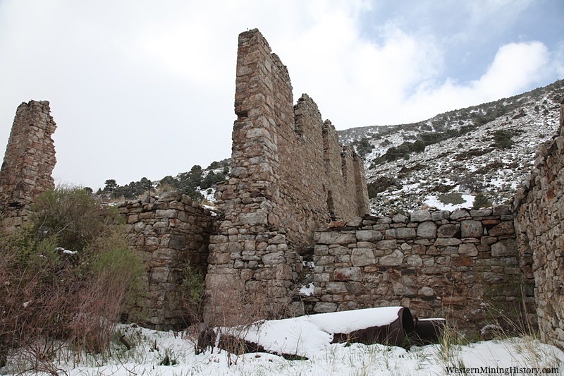
Kingston Canyon
Bunker Hill began two miles up the Canyon in 1863 and thrived till Kingston was laid out in 1864. Compared to the previous camps Kingston was a Metropolis. By 1867 they had two twenty stamp
mills hammering away at their low grade ore and in eight years they had four amalgamating mills. Kingston had it all, unlimited water power, vineyards, lumber, room for building and gardens and ‘’inexhaustible rich quartz ledges’’. George Hearst of Hearst, Haggin and Tevis optioned the property at one time but wisely invested his money and expertise into the Homestake mine in South Dakota instead. In 1868 the Victorine was rumored to produce fortyfive dollar ore. Lead and copper ore was worth 4.50$ an ounce due to it’s gold content. Wood sold for 4 to 5 dollars a cord and salts used in the milling process were available ten miles distant on the alkali flat. Local farming must not be underestimated. In 1878 John Muir wrote,
The immense expanse of mountain-girt valleys, on the edges of which these hidden ranches lie, make even the largest fields seem comic in size. The smallest, however, are by no means insignificant in a pecuniary view. On the east side of the Toyabe Range I discovered a jolly Irishman who informed me that his income from fifty acres, reinforced by a sheep range on the adjacent hills, was from seven to nine thousand dollars per annum. His irrigating brook is about four feet wide and eight inches deep, flowing about two miles per hour. Mr. Irwin has reclaimed a tule swamp several hundred acres in extent, which is now chiefly devoted to alfalfa. On twenty-five acres he claims to have raised this year thirty-seven tons of barley. Indeed, I have not yet noticed a meager crop of any kind in the State. Fruit alone is conspicuously absent.
Placer mining was promising around the turn of the century and about 1909 the Kingston Company ran a sixty stamp mill with two shifts. In May a 600$ bar of Gold was shipped and the town was booming. The cyanide plant was saving 90 to 95% of the ore’s value. In September 390 oz of Silver were produced. In 1928 a rush to Kingston was reported in the Tonopah news. This proved to be on ground patented forty years before.
Park Canyon
The North Twin River District was organized in 1863. For two years a ten stamp mill from Yankee Blade worked the ore. Silver mining has been revived in the 1880’s, and in the first decade of the 1900’s. A former Hawaiian Monarch is said to have owned several mines in this area.
Millett
Millet was the freighting center for the Toquima and Toiyabe mines. It had saloons, stores, post office, wagon repair and the Lakeview Hotel. A Charles Scheel built a ranch in 1873 that Mike Millet bought in 1896. In 1905 the Round Mountain and Manhattan booms sent prospectors careening into the knooks and crannys of the East slope of the Toiyabes seeking rich leads. 200$ to the ton ores were found west of Millet ranch in 1906 and telephone service was extended north and south. Streets and lots were platted and mining development began. A three foot ledge with 5000$ to the ton ore was discovered with a desiccated skeleton beside at what was soon to be called Pueblo. A new district was formed at the Millett store. The ore was mostly gold but there was some silver. The Nevada National co. operated a five stamp mill from1911 to 1913 and there was continuous production till 1916. The mines have also been worked intermittently since 1927
Darroughs Hot Springs
On November 16 1845 Fremont camped on the boiling springs. He reported the natives had used the area for centuries. They scared the locals off and the brave were seduced with offers of candy, calico,
beads and food. Fremont broke his thermometer testing the water and proclaimed the springs the hottest on earth. They test at 242 degrees. Further research tells us the Makushkin Volcano fumaroles at 310 degrees are actually the hottest in America. The waters here are plenty hot for cooking food.
Big Smoky Valley
State Historic marker no. 42
Named for its hazy distances, this Valley has seen a parade of famous men and stirring events. Prior to the White man the valley and its bordering Toiyabe and Toquima Ranges were favorite Shoshone haunts. Jedediah Smith, intrepid trapper and trailblazer was the first white man here. crossing the valley‘s southern end from the west in 1827. In 1845 came John C. Fremont, accompanied by such figures of the American West as Kit Carson and Basil la Juenesse. In 1859 Capt. James Simpson located the ‘’Central’’ Route across the Valley’s northern end. Thus began the historic decade 1859-1869, which saw Chorpennings Jackass Mail, the Pony Express, the Overland Telegragh and the concord coaches of the Overland Mail and Stage co. crossing the valley. Silver strikes at Austin )1862-1863) initiated the valley’s first mining boom. Numerous bustling mining camps sprung up: Bunker Hill, Kingston, Geneva, Santa Fe, Ophir Canyon, Jefferson etc. Following the 1900 Tonopah silver strike, mining surged again. During this interlude, two new towns, Manhattan and Round Mountain, started with a brief revival of many earlier camps.
Ophir
State Historic Marker no. 64
Well up into the canyon out yonder one can still see the massive stone foundations of a costly and splendid stamp mill, as well as the stone foundations of an elegant office and mansion. Here was the secene of a once busy place, now a ghost town. Ore was discovered there in 1963 by a S. Boulerand and his compatriots. In 1864, the Murphy mine was discovered and became the leading producer: A mining district was organized. During 1865 a twenty stamp mill was completed costing over 200,000$. Connected with it was the first experimental Stetfeldt furnace ever built. When the Murphy Mill was built, a town was started and it grew to a population of 400, but work in the mines declined in the 1870’s and Ophir became almost deserted. In the 1880’s the mines were reactivated and Ophir had another period of prosperity. By the 1890’s the town was deserted, but some mining activity at the Murphy mine continued sporadically into the 20th Century. Over Two Million dollars worth of Gold and silver were mined from the Murphy vein and from surrounding properties. Iron, Copper and Arsenic were also found in the area. Ophir managed to have all the accouterments of a large community, school, church, various lodges and of course, several saloons.
Bibliography
Nevada Ghost towns and Mining Camps Atlas Stan Paher
Nevada Historical Society, Reports and Research
Nevada Dept. of Transportation, Research Library
Romancing Nevada’s Past Shawn Hall
Nevada’s Turbulent Yesteryear C. S. Gallivant
History of Lander County Rene Lemaire
History of South Central Nevada D. Berg
Steep Trails John Muir
Atlas of Nevada Conifers David Charlet
1980 GENO OLIVER STAR CITY-UNIONVILLE
1981 SKIP PENNINGTON* MANHATTEN
1982 BILL KENNEDY KENNEDY
1983 JIM CRONN* PINEGROVE
1984 GEORGE COURSON LEADVILLE
1985 DOUG WALLING BERLIN
1986 DAVID WOOD ROCHESTER
1987 JOE LEPORI AURORA
1988 BILL SAWYER* SULPHUR
1989 MIKE MILLER MILLER’S STATION
1990 RED BEACH” SHAMROCK
1991 BOB RODGERS COMO
1992 RON WALSH SEVEN TROUGHS
1993 DANNY COSTELLO THE REAL NATIONAL
1994 JIM GROWS DESERT WELLS
1995 DANIEL BOWERS HIGH ROCK CANYON
1996 PETER VAN ALSTYNE+ FAIRVIEW
1997 EDDY GONZALES GRANTSVILLE
1998 JOHN DORNSTAUDER HUMBOLDT CITY
1999 KEN MOSER BELMONT
2000 VAL COLLIER PEPPER SPRINGS
2001 CHUCK MURRAY NIGHTENGALE
2002 MARC BEBOUT NEW PASS MINE
2003 AL NICHOLSON lONE
2004 RON THORNTON FLETCHER STATION
2005 J D PATERSON APPLEGATE-LASSEN TRAIL
2006 WALT SIMMEROTH NEVADA CENTRAL R. W.
2007 JEFF JOHNSON ADELAIDE
2008 OWEN RICHIE TYBO
2009 KARL SMALL DUN GLEN
2010 DAN WESTON KINGSTON
“Gone to Silver Hills + X Proctor, See More